


1923 Prairie Grain Elevator Historical Map - Laminated
1923 Prairie Grain Elevator Historical Map - Laminated
Couldn't load pickup availability
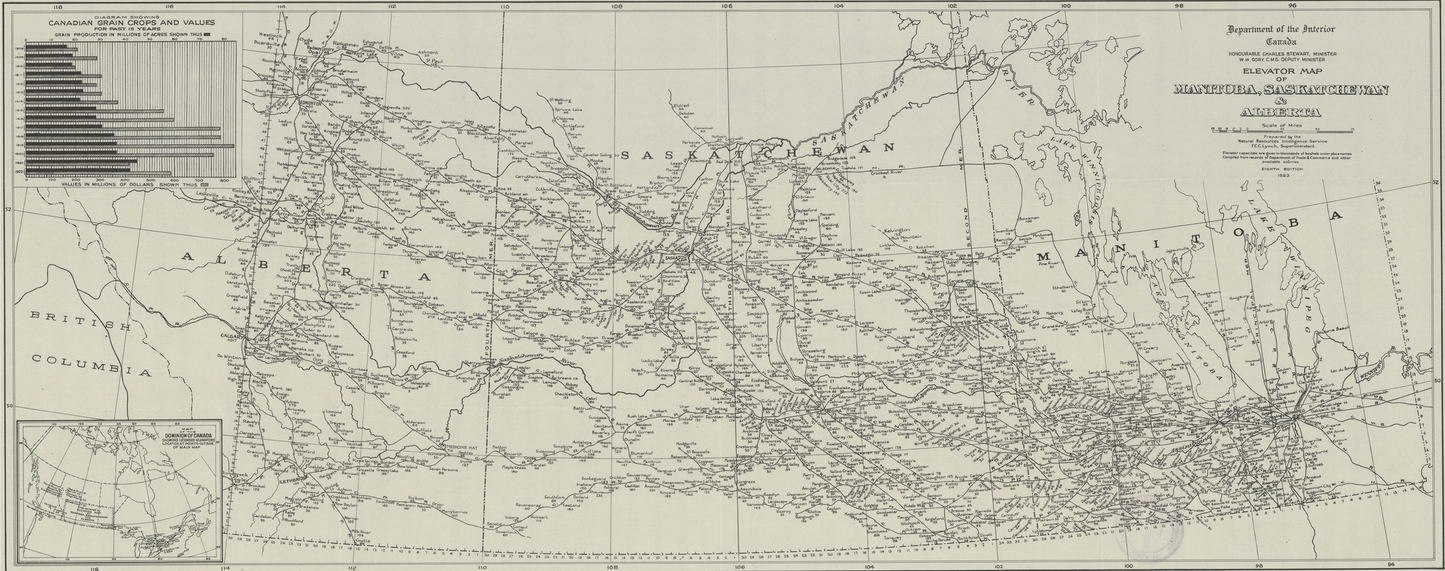
Authentic 1923 Prairie Grain Elevator Map
This detailed historical map, by the Department of the Interior Canada, showcases all the grain elevators and towns across the Canadian prairies from 1923 - a fascinating glimpse into prairie agricultural history with historic grain pricing and elevator capacities in bushels.
🌾 Interactive Online Experience
Before purchasing, explore our interactive online version where you can:
- Add your family farm's location and details
- Connect your farm to the nearest historical grain elevator
- Share your farming heritage story (farm name, years established, operational timeline)
- See how many families farmed across the prairies
- Discover connections between farms and their local elevators
📍 Physical Map Details
- Original 1923 grain elevator locations across Alberta, Saskatchewan, and Manitoba
- High-quality reproduction of historical document
- Perfect for genealogy research, family history, or historical interest
- Would look good in a shop, basement, or anywhere in your house
- Available in two sizes: Large (1829x750mm) and Standard (914x375mm)
Note: The physical map you purchase is the original 1923 historical map without personalized farm details. The interactive features are available online to explore prairie farming heritage and community connections.
Whether you enjoy iconic maps, researching family history, studying prairie settlement patterns, or simply love historical maps, this piece captures an important era in Canadian agricultural development.
Share


Pick the right size for your wall
Both sizes ship rolled in a reinforced mailing tube. Laminate is glare-resistant and wipes clean.
-
Ships in 2–5 business days
Canada Post tracked shipping from Alberta. You'll receive a tracking number the moment it leaves the print shop.
-
Built to last
Commercial-grade laminate on both sides. Glare-resistant, wipe-clean, and ready to hang straight out of the tube.
-
Archival quality
High-resolution reproduction of the 1923 Department of the Interior map, printed on materials engineered to hang for decades — not seasons.
Frequently Asked Questions
Shipping & tracking
Every map ships via Canada Post tracked shipping, typically within 2–5 business days of ordering. Each package includes a tracking number emailed to you once the label is generated.
Orders are shipped from Alberta in a reinforced mailing tube to keep the map flat and protected in transit.
Returns & damage policy
All sales are final — we do not accept returns or exchanges. Please use the size guide above and variant dropdown to pick the right map for your space before ordering.
That said, if your map arrives damaged in transit, email us within 7 days of delivery with photos of the package and product and we'll make it right.
Do I need a frame?
No frame required. The map ships laminated on both sides with a commercial-grade finish that's glare-resistant and wipe-clean. Use 3M Command strips, thumbtacks through the corners, or clips — it's a wall piece straight out of the tube.
If you'd prefer a framed look, the Large variant fits a standard 72" × 30" poster frame.
Do you ship internationally?
Yes. We ship to the US and most international destinations. Rates and transit times are calculated at checkout based on your address and the size you pick.
Note that international orders may be subject to import duties or taxes charged by the destination country — these aren't included in the checkout price.
How do I care for the laminate?
The laminate is engineered for everyday use. A damp microfibre cloth handles dust and smudges; a drop of mild soap tackles anything stubborn. Avoid ammonia-based cleaners (Windex, etc.) — over time they can dull the glare-resistant finish.
Keep it out of long-term direct sunlight to prevent fading on the printed inks.